The studio aimed at deriving a spatial plan and urban design-oriented solution for the issues faced by the people of Forest Park, IL a western suburb of Chicago. Based on the background study, demographic analysis and community outreach the team devised the following approach -
“Focusing on three key areas of efficiency, inclusivity, and
sustainability the intervention - “Green Mutualism” is centered
on the connectivity of people with each other and their surroundings
for a site feasible to implement both green- and mobility-related
tactical strategies believed to bridge the gaps presented in the community.
Monorail station vicinity mapping
(Group Project : work here shows my contribution)
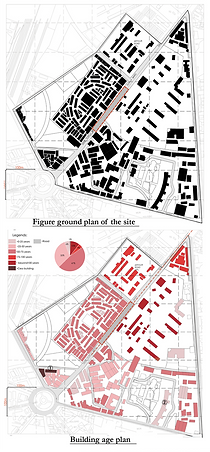
This project was developed in collaboration with Ratan J. Batliboi Consultants Pvt. Ltd., a Mumbai-based architecture firm leading the Phase II station development for the Mumbai Monorail. As part of the study, my team and I conducted site visits and collected primary data on existing land use, ownership patterns, building age, and related parameters. These datasets were manually mapped and analyzed to enable a comparative assessment of the site conditions. Additionally, a detailed 3D model was developed to better understand land-use distribution, massing, and the surrounding urban context.
.png)
3d model of the proposed monorail station and its surroundings