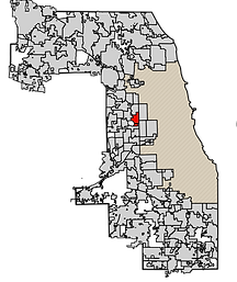
The studio aimed at deriving a spatial plan and urban design-oriented solution for the issues faced by the people of Forest Park, IL a western suburb of Chicago. Based on the background study, demographic analysis and community outreach the team devised the following approach -
“Focusing on three key areas of efficiency, inclusivity, and
sustainability the intervention - “Green Mutualism” is centered
on the connectivity of people with each other and their surroundings
for a site feasible to implement both green- and mobility-related
tactical strategies believed to bridge the gaps presented in the community.
Forest Park: A Story of People & Place
(Teamwork: work here shows my contribution)
The studio sought to develop a community and urban design-oriented solution to the issues confronting the residents of Forest Park, IL, a western suburb of Chicago. Through spatial planning analysis and scenarios, it aimed to gain a better understanding of spatial patterns, land use, and activities in the Forest Park community.
Topics explored
-
Background study,
-
Demographic analysis, and
-
community outreach
-
Transect study
-
Site study and design intervention


Forest Park Plan highlighting the three transect - CVS (top), East side view of the Portillos transect Altenheim (middle) and Portillos (bottom)
AIM
Focusing on three key areas of efficiency, inclusivity, and
sustainability the intervention - “Green Mutualism” is centered
on the connectivity of people with each other and their surroundings
for a site feasible to implement both green- and mobility-related
tactical strategies believed to bridge the gaps presented in the community
The Transects
Transect I -The first transect, “the former CVS area, ”is located at the northeastern corner of the Village, at the intersection between Circle Ave and Harlem Ave. This specific area was selected because the CVS building
and surrounding parking lot have recently become vacant, presenting a great opportunity for redevelopment. Additionally, the area is highly accessible as it is located right across the Harlem/ Lake Green Line CTA stop and is facing the entrance of the Village from the Oak Park side. The surrounding buildings are predominantly new construction with mixed use projects, making this transect highly suitable for creating a transit-oriented development project (TOD) that could transform the neighborhood.


View of Main street access and pivotal aspects
of the CVS Transect

South elevation of the CVS transect

West elevation of the CVS transect
CVS Transect land use plan
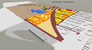
Transect II -The second transect, referred to as “the Altenheim area”, lies along Van Buren St and is close to the
intersection of Madison St. This site specifically attracted our attention due to its high accessibility, its link to Madison St ‒ one of the main streets that is considered the downtown, its proximity to one of the main elderly enclaves, and its potential to become a complete project on its own as it presents an open canvas for planners to shape. Unlike the other two transects, this one focuses more on green-oriented activities than mobility related ones, although it integrates both. This idea was also inspired by our meetings with stakeholders which highlighted that this area already attracts relaxation and recreation, but differently-abled people have a hard time navigating small bike lanes and uneven surfaces.

Altenheim Transect land use plan

View of Main street access and pivotal aspects of the Altenheim Transect

West elevation of the Altenheim transect

North elevation of the Altenheim transect
Transect III -Moving further south, the third transect ‒ named the “Portillo’s area” ‒ is situated along one of the main thoroughfares, Roosevelt Road, and intersects with Des Plaines Ave. This area is highly concentrated with automobile services as well as vast and underutilized parking lots for surrounding retail such as Portillo’s, Walmart and the Living Word Christian Center. Although these existing entities might present a challenge to achieve our ideal intervention, we see it as an opportunity to create a green micro-mobility project that will transform the area in “tactical” ways.


View of Main street access and pivotal aspects of the Portillos Transect

East elevation of the Portillos transect

West elevation of the Portillos transect
Altenheim Transect land use plan

Design intervention
Design Intervention -based on all the transect evaluation, the altenheim was chosen the primary site of development. The team proposed Three alternatives for this site also located near the Blue Line forest park station. The plan (below) was the second option designed on the principles of “Green movement,” which was based on mobility-driven activities designed by me. The views here (below) represent the 3d models made by for all the three alternatives proposed for the same site and where developed by me. The top two model focused on just single principles of green connectivity and green mobility, while the bottom model ( the chosen alternative) amalgamated both of these aspects creating a green expanse.

Plan of alternative 2 - Green Movement Plan

Plan of alternative 3- Green Expanse Plan

Alternative 1 - Green Connectivity view

Alternative 2 - Green Movement view

Alternative 3 - Green expanse view
