
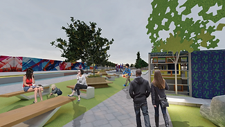
The studio aimed at deriving a spatial plan and urban design-oriented solution for the issues faced by the people of Forest Park, IL a western suburb of Chicago. Based on the background study, demographic analysis and community outreach the team devised the following approach -
“Focusing on three key areas of efficiency, inclusivity, and
sustainability the intervention - “Green Mutualism” is centered
on the connectivity of people with each other and their surroundings
for a site feasible to implement both green- and mobility-related
tactical strategies believed to bridge the gaps presented in the community.

People's tomorrow: Humboldt Park
(Group project: work here shows my contribution)
The goal of this project was to collaborate on a real-world planning problem and create a plan document demonstrating design and policy intervention based on
-
Site analysis
-
Community outreach
-
Issue area derivation
-
Design intervention
for the Chicago neighborhood of Humboldt Park In addition to the strategies, the team created an implementation table to analyze the short, medium, and long-term actions items.
The following graphics and text provide an overview of my contribution to the plan document

Humboldt Park neighborhood map highlighting 6 focal projects envisioned for each issue area
Vision
"Humboldt Park’s identity is historically anchored by the many people and communities who have worked to make this neighborhood what it is. With this in mind, we envision a community that actively seeks the benefits that investment brings, while securing the rights of those who have made the community what it is today. This vision is community-informed and data driven supported by a set of strategies and actions spanning five critical issue areas: mitigating displacement, economic development, arts & culture, education, and climate & health. We recognize and intend the developed framework to be inter-sectional, in which programming and focal projects work across issue areas to achieve the greater vision of a vibrant, united, and resilient Humboldt Park for generations to come"
History of Humboldt park


The timeline above provides an overview of the history of Humboldt Park, how the neighborhood has evolved, the demographic changes it has witnessed, and how it has turned into the current day abode of the largest percent of the Puerto Rican population in Chicago, or as it is famously known the “Puerto Rico Town” which is located in the northeast part of the community. This designation of Puerto Rico town, the creation of the “Paseo Boricua” landmark, and the 606 trail brought in commercial and economic development in this area, especially in the north and east sides of Humboldt park. This has created an intangible divide between the north & east sides of the population and the south and west
side of the community.
Focal Projects

View of the “Ridgeway crafthouse”

View of the “ Unity Triangle “ public space

View of the public space at the “Ridgeway crafthouse”
View of the “ Unity Triangle “ kiosk and plaza
Focal Projects- Ridgeway craft house and Unity Triangle (left) were two of the focal projects 3d model that I designed.
The Ridgeway Craft house- was one of the focal projects for the Mitigating Displacement issue area, which was established to ensure the stability of both artists and community members. The project was proposed for two city-owned vacant plots classified RT-4 (Residential flat), surrounded by sparse houses and a mix of land uses. The proposal was for affordable, mixed-use artist housing with an open first-floor plan to foster creativity and serve a variety of uses such as dance/art studios, exhibitions, and much more, as well as adjacent outdoor space for community gatherings on the south-west side of Humboldt Park, with the goal of balancing the uneven development patterns that favor the east and northeast side.
Unity Triangle on the other hand was located on the Grand Avenue triangle plot which centrally bisected the community, intersecting all three priority corridors enlisted for development by the authorities. Primarily zoned as a combination of manufacturing, commercial, and restricted service districts, as of 2019 some of these central manufacturing areas had been replaced with residential two-flat, townhouses, and multi-unit buildings and a small neighborhood park, and more retail zoning districts have been added. Thus based on the new line of development around the site we proposed a public space on Grand Avenue to reactivate and enhance this key corridor. Wherein The project provides the opportunity for both temporary and permanent interventions in the form of plazas, play areas and kiosks.